Please be advised that the National Weather Service has issued a High Rip Current Risk Statement and a High Surf Advisory which arein effect through Saturday, Dec. 16.
Read the full statement.
A Coastal Flooding Statement is also in effect through Friday afternoon, Dec. 15.
Multiple Weather Hazards Expected This Week
Additionally, the National Weather Service (NWS) has issued an advisory in anticipation of an incoming disturbance that will affect conditions in the area for the rest of the week:
- Hazardous marine and beach conditions will increase in severity beginning Tuesday and prevail through late this week into the upcoming weekend. Dangerous rip currents, hazardous surf, and minor coastal flooding will be possible along the east coast of South Florida through late this week.
- A disturbance will lift northward into South Florida beginning on Wednesday bringing the potential of heavy rainfall across the area into the upcoming weekend. This could result in localized flooding concerns across southeastern Florida later this week.
- Winds will also remain elevated throughout the remainder of the week with gusts of 40+ mph possible along the immediate east coast of South Florida later this week.
More Information About Rip Current Safety:
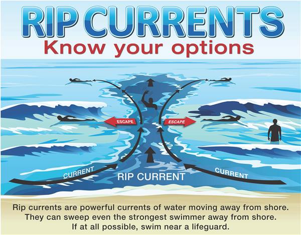
The Rip Current Risk alert warns of dangerous rip currents expected in the ocean. Rip currents have the potential to sweep even experienced swimmers away from the shore and into deep water.
For your safety, it is safest to avoid entering the ocean or any water activities at this time.
Always swim near a lifeguard. If caught in a rip current, do not swim against the current. If able, swim parallel to the beach. If you are unable to escape the tide, face the shoreline and call for help.
To view the Rip Current Statement and additional updates from the National Weather Service, please refer to: National Weather Service: Watches Warnings and Advisories.